Currently at anchor at Henry Island on the Illinois River.
We started to keep track of where we've stopped along the loop on a Google map, Where we've been
Wednesday, September 25, 2013

Tuesday, September 17, 2013
Whats new September 2013
All of our recent posts can be found at Where is BeachQuest blog.
We're currently on the way to Chicago and the river system. And hoping we'll be able to travel south quickly enough to escape those dastardly temperatures. Anything under 60 brings out the winter coats ... well, what we have for winter coats. Which isn't quite like the outwear we owned living in Wisconsin all those years.
Hopefully we'll catch up with Barefoot'n, Sea Glide, Papillon, Miss GG, ShellSeeker, and several others. We're trying!
September 22, 2013
... finds us at Heritage Harbor marina in Ottawa Illinois. We're here anticipating driving a rental car up to WI for my permanent crown and Mary's Dr. Appointment. If we cant work that out Monday we'll just head south and figure something out down near Alton. My verbal musing about the journey so far can be found here at our Where is BeachQuest blog
An interactive map of the journey so far is here
We're currently on the way to Chicago and the river system. And hoping we'll be able to travel south quickly enough to escape those dastardly temperatures. Anything under 60 brings out the winter coats ... well, what we have for winter coats. Which isn't quite like the outwear we owned living in Wisconsin all those years.
Hopefully we'll catch up with Barefoot'n, Sea Glide, Papillon, Miss GG, ShellSeeker, and several others. We're trying!
September 22, 2013
... finds us at Heritage Harbor marina in Ottawa Illinois. We're here anticipating driving a rental car up to WI for my permanent crown and Mary's Dr. Appointment. If we cant work that out Monday we'll just head south and figure something out down near Alton. My verbal musing about the journey so far can be found here at our Where is BeachQuest blog
An interactive map of the journey so far is here
Friday, August 9, 2013
Whats new
For anyone reading this looking for notes on our most current travels, I've been updating our where is BeachQuest blog more frequently.
Sunday, July 21, 2013
July 21 2013
It's difficult enough to keep up one blog. And two is... well you can see how I'm doing.
We have another blog, where we are now which I had intended to keep up to date with short little posting indicating where we are currently docked or anchored. It seems to have morphed in to a more full blown blogging effort. I'm still compiling notes and pictures here, but the more up to date posting are always at our where we are now blog.
We have another blog, where we are now which I had intended to keep up to date with short little posting indicating where we are currently docked or anchored. It seems to have morphed in to a more full blown blogging effort. I'm still compiling notes and pictures here, but the more up to date posting are always at our where we are now blog.
Sunday, June 9, 2013
June 9, 2013 Waterford

Well again we were up by 6am and moving up the creek by 6:15am. Today though there was no coffee. Not a big deal to some. Others have a more intense reaction. Even so we did get up. And half of us stayed awake for the whole trip.

It was cool, and very foggy. But on the river up here fog is common and usually burns off before 9am so with the radar on we went out the creek and into the Hudson. A rather mundane story except for the fuel barge going by at the very instant we emerged from the creek. Didn't see it until it was right on top of us. So it was either slow down, wait, and end up following the barge for several hours until we could pass him. Or gun it and beat him around the entrance to the creek.
 |
I gunned it. Well, gunned it maybe a bit of an overstatement. I went faster is probably more accurate. Remember we only move at a swift 7 mph.

The fog did burn off around 9am and we were treated to some great scenery. Reminds me of upper Michigan. The river here is still deep, 30-70 feet and right up to the bank. But it narrows quite a bit so we're navigating through cuts more than the a wide river. Or so it seemed.
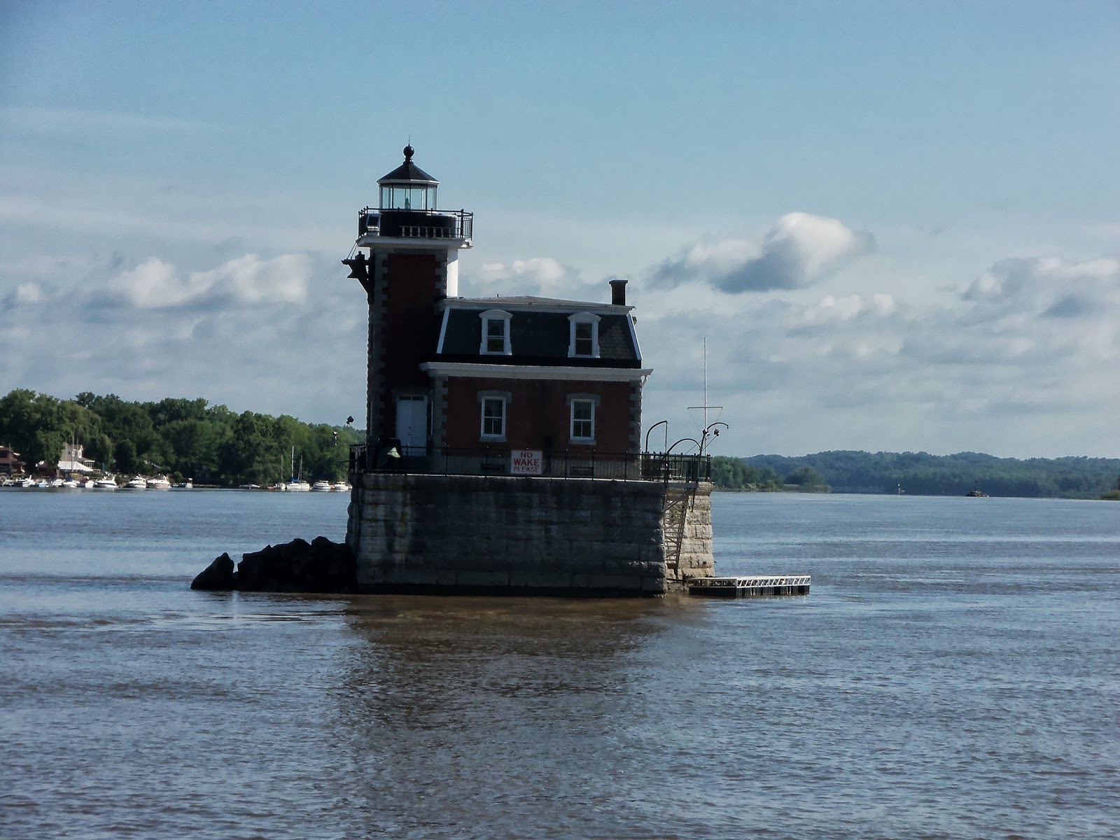 |
| Cute Lighthouses abound |
It was a nice day so there were many more boats out then we've seen before. Saw a few rafted up and a few others pulled up on the sandy portions of the shore.

We went through Albany and I was surprised to see an ocean going freighter that far up the river. Albany is a busy river port with many barges on the move. But after New York we're good at dodging big vessels.

We approached Troy and the first lock not knowing much about the New York locks and if they operated similarly to the locks we've been through on the Mississippi. Turns out they are pretty much the same. One small difference though. On the Mississippi we had a 30 foot boat which was fairly easy to handle. Its a bit different with the beast we have now. I'm sure as we go through the 200 some locks on this trip our locking procedures will be as smooth as silk. And I will admit we are currently debating the utility of headsets with 2-way voice communication so we can hear each other.

After locking through it was a short journey to this bridge with a published vertical clearance of only 20 feet. We can "barely" make that height if I take all the antennas down. So Mary drove and I took antennas down. We went through with 2 feet to spare. I found out later the pool was lowered today giving us 22 feet of air clearance. Yesterday the vertical clearance was only 18 feet!

Once through the bridge we came up to the Welcome Center free dock. There were a few spaces up on the floating piers but the fixed cement sidewall afforded much easier access on and off the boat so we went in there. A couple of older guys helped with the lines and spent 30 minutes with us telling stories about their loop adventure. Lucky they were there too since we're still collecting experience on docking by ourselves. I should point out our boat's deck sits about 4-5 feet above most floating docks and getting a line on a cleat that low requires aerobatic talents long since atrophied.

Jimmy the dock guy on Sunday is a quite a character. Great guy! Met a nice couple from Satisfaction, a Grand Banks 36 going along the same route we are. Also a couple of guys, on a sailboat we went through the lock with earlier.
We went to Mcgreiveys to eat and then I wrote this and went to bed.
Saturday, June 8, 2013
Cape May to New York
 |
| Area where I had to pivot the boat |
 |
| Harbor View marina (red roofs) |
 |
| Anchorage near the Coast Guard station in Cape May |
 |
| Cape May after leaving the inlet headed north |
 |
| Atlantic City about 10 miles out |
 |
| If your dryer vent isn't hooked up .... |
We chatted with a few other boats on the radio otherwise it was a sedate several hours. Mary did some laundry even though I haven't quite got the dryer vent completely hooked up yet.
 |
| Gadgets all lit up |
Once it got dark, it also became interesting. The night was pitch black, and a dense heavy fog rolled in after midnight. Radar became important as did the radio. I talked with at least ten other vessels from tugs, and tows to ships and some 80' sailing yacht from France. .
 |
| Jiggly radar picture with only 3 targets. |
Luckily it was calm and the radar display was very clear. The fog prevented seeing any running lights so radar was the only thing we could use to find other vessels. 7 targets was the most I had on the screen at one time.
 |
| Dawn off Sandy Hook |
Around 5:30am it began to get light as we passed by Sandy Hook. Made coffee and woke Mary up at 6:30 as we headed into New York Harbor. Yes, we were gawking at the skyline and big ships moving in and out just like a bunch of tourists. Only down side is that we also had to drive the boat ... and not into anything. We finally got a hold of Odyssy4 for a brief chat (they arrived before us and anchored near Coney Island).
 |
| Verrazano Bridge and the Narrows |

 |
| Anchorage entrance runs right along the sea wall back . |
We weaved our way through all the traffic and found the entrance to Liberty Park anchorage which is just behind the Statue of Liberty. It was a rather narrow entrance but the basin is pretty big except this time there were some construction equipment there. Also discovered a ferry runs in and out as well as a construction crew boat. So it wasn't all that peaceful and quiet. The holding was marginal, at least for us. We dragged and had to try three times to get the anchor to set which it finally did by putting out 100 ft. of chain. Luckily there were only two other boats in there at the time.
Once re-anchored, we settled in and I went to bed early. I've concluded I am way to old to stay up all night.
Monday, May 27, 2013
Heading to Norfolk May 21, 2013
Since I've been remiss in getting this blog updated recently I figure I'd publish a more recent adventure while trying to coordinate the massive number of pictures and notes I have into something more readable.
What a great little town Norfolk. I spent a few months here when I was in the Navy and it sure looks different now than it did back in 19 ... ah, mumble mumble. Ok, 1970. But I'm getting ahead of my self.
We were the 2nd to last boat to leave Coinjock marina. And not until 8:40am which is a more optimal time for us than these past 7am departure times we've been doing. We met some nice people there, Dona and Calvin off of New Fidelity a Nordhavn 57 were two. I met Donna as she was standing by the fuel pump. 600+ gallons takes a while to pump. Another couple were on a Fleming 55 docked right behind us (yes, I had to put out boat right if front of their Flemming and their Flemming is worth more than 10 of ours so I went very, very carefully). We were actually docked between the two boats. Guess we keep really good company.
When we left we pretty much had the dock to ourselves. So taking advantage of the situation we practiced taking off without anyone undoing our dock lines. It may be a work in progress, but we didn't smash into anything and while it may not have been a sight worthy of a Coast Guard boat handling training film, it got us off the dock and we were bestowed with another few grains of wisdom. By the time we're 100, we'll be able to drive anything.
 Fired up the water maker in Coinjock sound just north of Coinjock. We lost a membrane earleir and so the water maker is running ojn only two of its three membranse which means it only makes about 50 gallons and hour not 80 or 90. Have to run the generator too since it sucks a lot of power.
This journey led us through the Albemarle and Chesapeake Canal, 20 some miles of ditch through forest lands with bridges!. At least it was deep though so no shoaling worries. Only saw 1 other boat through the whole thing and that boat passed us. Yes, it was another sailboat. And your correct if you've deduced that we will never be isseud a speeding citation.
Into Virginia we began running into more bridges making the going slow since they open on the hour or half hour and the distance between the bridges isn't always conducive for a specific arrival time. There seems to be more swing bridges than normal opening spans. But the bridge tenders were all colorful characters and very nice.
Not much vertical clearance. The road ways never seemed too heavily traveled but nonetheless the bridges adhere to a fixed opening schedule.
Went thru Great Bridge after idling around for 20 minutes. Ever try keeping a big boat within a small area with wind and current undoing every steadying maneuver you attempt trying to stay within a small area and not crash into several other boats struggling to do the same? That's how I spell fun!
After 20 minutes the bridge opened and everyone shoots through there right to the Virginia Cut Lock. The lock has a port side which is rubber coated walls and a starboard side with concrete walls. We of course, chose the concert wall since we had fenders out and I, being right-handed, just figured that was the way to go. No boat damage but the fenders were not all that useful. Another lesson learned.
The nice Lockmaster lady was very helpful and even commented twice on how nice a dog we had. Of course Cleo immediately leaped off the boat and began rolling in whatever fetid material she could find along the lock wall just as the lock doors closed bringing the official looking sign stating DO NOT LEAVE YOUR BOAT into clear view. So the dog had a great time, the Lockmaster had another stupid boater story and Mary and I were snarling at each other trying to keep the boat from smashing into the lock wall as the surging water filled the lock. Cleo frolicked and rolled much to the chagrin of us but to the delight of the lock master lady. As the gates opened to let us out Cleo, sensing her life maybe in danger, wisely leaped back on the boat just as the boat in front of us took off.
Running into Norfolk one passes through an industrial area with much shipping and ship traffic. Very interesting place. BUt very busy. It began raining again as we made the turn up the Elizabeth river so all my good ship pictures turned out awful.
 We passed a few Navy ships in dry dock and there were these ever
vigilant security boats in front of every one. If your course deviated
towards them and the navy ships they'd turn towards you. I chose to
run a course as far from them as possible.
We passed a few Navy ships in dry dock and there were these ever
vigilant security boats in front of every one. If your course deviated
towards them and the navy ships they'd turn towards you. I chose to
run a course as far from them as possible.
 We anchored at hospital point which is right in front of a big hospital. There are several marina's very close by and the USS Wisconsin (BB64) was right across the river. There were about 6-7 boats in the anchorage and the weather was pretty settled so no worries. We hauled the dinghy down to run Cleo over to a park where the naval museum and battleship are located. There is a little unused marina right next to the Wisconsin where we tied up. Convenient!
 BB64 is big, big ship. Oddly it has teak decks, something us older boat owners shy away from. The condo building surrounds the ship berth.
Seems our KVH satellite has ceased to provide a signal. I'm guessing our free-be DISH account has bit the dust. Alan, the former owner is a sweet man. He gave us free satellite TV through his DISH account until June and I think it's finally over. Mary is almost devastated but is too tired to complain much. I dont watch TV much at all so no loss for me. But we will have to straighten out the DISH account stuff in the next few days.
These long 50 mile days though navigation challenges can be exhausting. We went to bed early!
What a great little town Norfolk. I spent a few months here when I was in the Navy and it sure looks different now than it did back in 19 ... ah, mumble mumble. Ok, 1970. But I'm getting ahead of my self.
 |
| Empty dock in the morning |
When we left we pretty much had the dock to ourselves. So taking advantage of the situation we practiced taking off without anyone undoing our dock lines. It may be a work in progress, but we didn't smash into anything and while it may not have been a sight worthy of a Coast Guard boat handling training film, it got us off the dock and we were bestowed with another few grains of wisdom. By the time we're 100, we'll be able to drive anything.
 Fired up the water maker in Coinjock sound just north of Coinjock. We lost a membrane earleir and so the water maker is running ojn only two of its three membranse which means it only makes about 50 gallons and hour not 80 or 90. Have to run the generator too since it sucks a lot of power.
 This journey led us through the Albemarle and Chesapeake Canal, 20 some miles of ditch through forest lands with bridges!. At least it was deep though so no shoaling worries. Only saw 1 other boat through the whole thing and that boat passed us. Yes, it was another sailboat. And your correct if you've deduced that we will never be isseud a speeding citation.
 |
| Going through a swing bridge |
 | |
| Typical Swing Bridge |
 | |
| Great Bridge |
After 20 minutes the bridge opened and everyone shoots through there right to the Virginia Cut Lock. The lock has a port side which is rubber coated walls and a starboard side with concrete walls. We of course, chose the concert wall since we had fenders out and I, being right-handed, just figured that was the way to go. No boat damage but the fenders were not all that useful. Another lesson learned.
 |
| Virginia Cut Lock. |
 |
| Entering the Norfolk Shipping port through, what else, but another bridge. |


Seems our KVH satellite has ceased to provide a signal. I'm guessing our free-be DISH account has bit the dust. Alan, the former owner is a sweet man. He gave us free satellite TV through his DISH account until June and I think it's finally over. Mary is almost devastated but is too tired to complain much. I dont watch TV much at all so no loss for me. But we will have to straighten out the DISH account stuff in the next few days.
These long 50 mile days though navigation challenges can be exhausting. We went to bed early!
Subscribe to:
Posts (Atom)